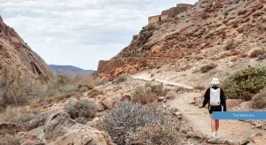
Fuerteventura, with its arid landscape, offers a wide variety of hiking routes ranging from volcanic trails to coastal paths. Here is a selection of the best treks on the island, with practical information on difficulty, distance, accessibility and useful tips.
Calderón Hondo – Lajares
Difficulty: Easy Distance: 4.7 km (loop) Elevation gain: 150 m Duration: 1h 30min Starting point: Lajares Coordinates: 28.6990° N, 13.9210° W
Perfect for families and beginners, this trail leads to the edge of a volcanic crater with spectacular views over the island and Lanzarote. Well marked and well trodden, with viewpoints and geological information along the way.
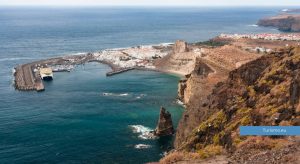
Las Cuevas Negras – Ajuy
Difficulty: Easy Distance: 2.5 km (out and back) Elevation gain: 100 m Duration: 1 hour Starting point: Ajuy village Coordinates: 28.4230° N, 14.1980° W
A short walk along the cliffs to the ancient volcanic caves of Ajuy — one of the geologically oldest sites in the Canary Islands, where lava meets the sea. Perfect for a brief excursion before or after lunch at one of the local fish restaurants.
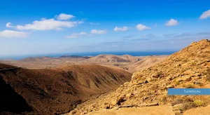
Camino de las Calderas – Corralejo
Difficulty: Easy – Moderate Distance: Approx. 6–7 km (loop) Elevation gain: 120 m Duration: 2 hours Starting point: Dirt track between Lajares and Corralejo, near Morro Francisco (Corralejo)
A circular route winding through ancient volcanic craters, scoria cones and lava outcrops in the north of the island. The trail offers constant views over the ocean and nearby Lanzarote. Quiet and off the beaten track — ideal for those seeking a hike in complete silence.
Malpaís de la Arena – Villaverde
Difficulty: Easy – Moderate Distance: 8 km (loop) Elevation gain: 150 m Duration: 2–2.5 hours Starting point: Villaverde
A loop through an ancient lava field (malpaís) around the volcanic cone of Montaña de la Arena. The landscape is almost Martian, and you may encounter wild goats, donkeys appearing from behind old dry-stone walls, and resilient plants such as aeonium.
Montaña de Escanfraga – Villaverde
Difficulty: Moderate Distance: 6 km (out and back) Elevation gain: 300 m Duration: 2–2.5 hours Starting point: Villaverde
Montaña de Escanfraga is the highest volcanic cone in northern Fuerteventura (529 m). The panoramic trail offers spectacular views over Corralejo, Lajares and the ocean. Archaeological remains — ancient stone enclosures — can be found at the summit.
Caldera de Gairía – Tiscamanita
Difficulty: Moderate Distance: 7 km (loop) Elevation gain: 296 m Duration: Approx. 2h 30min Starting point: Tiscamanita Coordinates: 28.4157° N, 14.0300° W Recommended period: August–January (closed during Egyptian vulture nesting season: 15 Feb – 31 Jul)
A scenic circular route around and over the crater of one of the island’s most striking volcanoes. Lava landscapes, endemic flora and, with a little luck, raptors soaring overhead.
Degollada de los Granadillos
Difficulty: Moderate Distance: 6 km (out and back) Elevation gain: 300 m Duration: 2.5 hours Starting point: Between Pájara and Toto (on the FV-30)
A quiet trail connecting two valleys through an ancient mountain pass. Excellent views over the southern part of the island and the Rural Park of Betancuria. Best in autumn or winter.
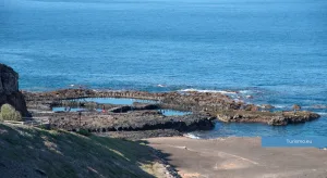
Barranco de las Peñitas
Difficulty: Easy – Moderate Distance: 6 km (out and back) Elevation gain: Approx. 200 m Duration: 2 hours Starting point: Buen Paso (next to the Ermita de la Peña) Coordinates: 28.3858° N, 14.1060° W
One of the most spectacular landscapes on the island — a canyon carved over time by waters long since gone. Ideal for those seeking a striking experience without too much effort. Some short rock scrambles along the way.
Camino del Cardón to the Ermita de la Virgen del Tanquito
Difficulty: Easy – Moderate Distance: 4 km (out and back) Elevation gain: 150 m Duration: 1h 30min Starting point: El Cardón village
A short but captivating trail to a small isolated chapel, once used for ancient rural religious celebrations. The area offers a surprising view over the south-western interior — eroded mountains and total silence.
Pico de la Zarza – Morro Jable
Difficulty: Moderate – Challenging Distance: 13 km (out and back) Elevation gain: 807 m Duration: 4–5 hours Starting point: Morro Jable (Hotel Jandía Princess or Mirador del Pico) Coordinates: 28.1017° N, 14.3558° W
The highest peak in Fuerteventura (807 m) offers a spectacular view over Cofete. A steady climb, but never too technical. The summit is often shrouded in mist, but the sense of achievement is guaranteed.
Other trails
Beyond the well-known routes, Fuerteventura offers a network of itineraries promoted by the Ecofuerteventura project — marked trails crossing unspoilt landscapes and connecting points of natural, cultural and rural interest.
Ecofuerteventura: trail map (in Spanish and English)
Practical tips for hiking in Fuerteventura
Even on easier routes, hiking boots are recommended as the terrain is often rocky or sandy. The island is hot and dry — carrying at least 1.5 litres of water is essential on any trail. A hat, sunglasses and sunscreen complete the basic kit.
Wind can be very strong, especially at altitude, so take care on exposed ridges.
Hiking apps
Komoot, Wikiloc and AllTrails all offer offline maps, GPS tracks and up-to-date user reviews.
Explore the island step by step: every trail tells a story thousands of years in the making — wind, lava and ocean.